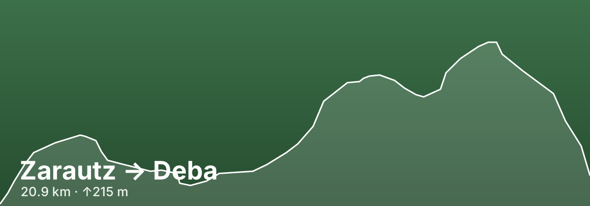
Zarautz → Deba
A stage of the Camino del Norte
This Camino del Norte stage covers about 21 km of the Gipuzkoa coast and is far hillier than the map suggests: guidebooks count roughly 700 m of cumulative ascent spread over three or four real climbs. Right outside Zarautz you choose between the official inland line, which climbs a cobbled medieval way through txakoli vineyards past the Santa Bárbara viewpoint and over the Alto de Garate (282 m), and the flat seaside promenade beside the N-634 to Getaria, the fishing town of Juan Sebastián Elcano. Both branches meet near Askizu and drop to the port of Zumaia (around km 9), where the route crosses the Urola and Narrondo rivers. From there the Camino turns inland, climbing past the Arritokieta chapel to the hamlet of Elorriaga and on through farmland and woods to the hilltop sanctuary of Itziar (around km 18), before a steep final descent of some 300 m past the Ermita de San Roque and down a stone way and zigzag stairs into Deba.
- 20.9 kmDistance
- ↑215 m ↓189 mElevation
- ModerateDifficulty
- 44 kmfrom route start
Highlights
- The medieval cobbled way and txakoli vineyards climbing out of Zarautz, with the Santa Bárbara viewpoint over the beach
- Getaria: the Gothic church of San Salvador, the Elcano monument, the Balenciaga Museum and the 'mouse'-shaped headland of San Antón
- Zumaia's fortress-like church of San Pedro and, a short detour away, the flysch cliffs of Itzurun beach in the UNESCO Basque Coast Geopark
- The Sanctuary of Itziar on its hilltop, home to a venerated 13th-century Romanesque image of the Virgin long honoured by Basque sailors
- The Ermita de San Roque with its pilgrim iconography and Deba's Gothic church of Santa María la Real with its painted portal
Tips
The seaside promenade to Getaria is easier and lets you visit the town, but avoid it in storms with heavy surf; the inland official route is harder but beautifully waymarked. In Zarautz a panoramic lift can save the first stretch of the steep climb. Zumaia, with a municipal pilgrim albergue in the San José convent, is a good place to split the day if you want time for the flysch, and the unofficial GR-121 variant past the Sakoneta cliffs is only advisable in good weather. After Zumaia services thin out, so carry water and food for the climbs to Itziar. Just past Elorriaga the route crosses the N-634 on a bend with no pedestrian crossing, so take care. The steep cobbled descent into Deba is hard on tired knees, especially when wet. Deba's pilgrim albergue is in the old railway station, but you usually check in and get your bed at the tourist office first, so check its hours (it closes at midday) and arrive early in summer. The next stage to Markina-Xemein is one of the loneliest on the Norte, so stock up in Deba.
Towns on this stage
Find accommodation in Deba →Distances and elevation come from real OpenStreetMap footpath geometry. In the planner you can split or merge any stage to match your pace.