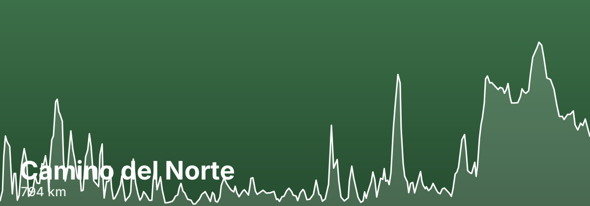
Camino del Norte
Beyond the coastal scenery, the Norte strings together some of northern Spain's most rewarding cities and villages: the beaches and pintxos bars of San Sebastián, the Basque heart of Gernika and Bilbao, and the seaside towns of Cantabria and Asturias before the route turns inland through green Galician countryside to meet the Camino Francés at Arzúa. Because it passes through larger cities and popular resort towns, services, transport links, and food are easy to find, though it sees fewer pilgrims than the Francés and stretches can feel quiet. Expect a mix of clifftop paths, town walking, and rural lanes rather than one continuous trail.
- ~794 kmtotal distance
- 31stages
- ~33 days at 20-25 km/daytypical days
- Late May to June, Septemberbest season
Highlights
- La Concha bay and old-town pintxos in San Sebastián
- The Guggenheim Museum and Casco Viejo of Bilbao
- The cobbled medieval streets of Santillana del Mar
- The welcoming pilgrim albergue at Güemes
- The Cistercian monastery at Sobrado dos Monxes in Galicia
Stages
| # | Stage | Distance | Elevation | Difficulty |
|---|---|---|---|---|
| 1 | Irún → San Sebastián · guide → | 23.7 km | ↑383 ↓388 m | Moderate |
| 2 | San Sebastián → Zarautz · guide → | 20.5 km | ↑262 ↓214 m | Moderate |
| 3 | Zarautz → Deba · guide → | 20.9 km | ↑215 ↓189 m | Moderate |
| 4 | Deba → Markina-Xemein · guide → | 21.9 km | ↑413 ↓401 m | Moderate |
| 5 | Markina-Xemein → Gernika · guide → | 23.5 km | ↑276 ↓346 m | Moderate |
| 6 | Gernika → Bilbao · guide → | 30.7 km | ↑489 ↓474 m | Challenging |
| 7 | Bilbao → Portugalete · guide → | 16.8 km | ↑187 ↓179 m | Moderate |
| 8 | Portugalete → Castro-Urdiales · guide → | 32 km | ↑253 ↓286 m | Moderate |
| 9 | Castro-Urdiales → Laredo · guide → | 28.3 km | ↑260 ↓216 m | Moderate |
| 10 | Laredo → Güemes · guide → | 28.6 km | ↑100 ↓102 m | Moderate |
| 11 | Güemes → Santander · guide → | 19.4 km | ↑20 ↓63 m | Easy |
| 12 | Santander → Santillana del Mar · guide → | 35.9 km | ↑189 ↓100 m | Moderate |
| 13 | Santillana del Mar → Comillas · guide → | 20.4 km | ↑37 ↓105 m | Easy |
| 14 | Comillas → Colombres · guide → | 28.4 km | ↑137 ↓118 m | Moderate |
| 15 | Colombres → Llanes · guide → | 19.5 km | ↑25 ↓43 m | Easy |
| 16 | Llanes → Ribadesella · guide → | 29 km | ↑69 ↓86 m | Moderate |
| 17 | Ribadesella → Villaviciosa · guide → | 36.1 km | ↑149 ↓152 m | Moderate |
| 18 | Villaviciosa → Gijón · guide → | 27.6 km | ↑387 ↓388 m | Moderate |
| 19 | Gijón → Avilés · guide → | 25.6 km | ↑157 ↓151 m | Moderate |
| 20 | Avilés → Soto de Luiña · guide → | 29.1 km | ↑287 ↓173 m | Moderate |
| 21 | Soto de Luiña → Cadavedo · guide → | 20.8 km | ↑509 ↓171 m | Moderate |
| 22 | Cadavedo → Luarca · guide → | 19.9 km | ↑69 ↓490 m | Moderate |
| 23 | Luarca → La Caridad · guide → | 29 km | ↑138 ↓133 m | Moderate |
| 24 | La Caridad → Ribadeo · guide → | 20.6 km | ↑34 ↓54 m | Easy |
| 25 | Ribadeo → Lourenzá · guide → | 26 km | ↑298 ↓218 m | Moderate |
| 26 | Lourenzá → Abadín · guide → | 23.5 km | ↑488 ↓87 m | Moderate |
| 27 | Abadín → Vilalba · guide → | 20.9 km | ↑36 ↓96 m | Moderate |
| 28 | Vilalba → Baamonde · guide → | 19.1 km | ↑56 ↓95 m | Moderate |
| 29 | Baamonde → Sobrado dos Monxes · guide → | 37.6 km | ↑277 ↓167 m | Challenging |
| 30 | Sobrado dos Monxes → Arzúa · guide → | 21.3 km | ↑8 ↓176 m | Moderate |
| 31 | Arzúa → Santiago de Compostela · guide → | 37.1 km | ↑119 ↓201 m | Moderate |
The terrain is genuinely hilly, with repeated short but steep climbs and descents between coastal valleys that add up over the day, plus some road and pavement sections near the cities.
Distances and elevation come from real OpenStreetMap footpath geometry. In the planner you can split or merge any stage to match your pace.
Where to stay — Camino del Norte
- San Sebastián 21 albergues · 34 hotels · book
- Zarautz 9 albergues · 7 hotels · book
- Deba 1 albergues · 6 hotels · book
- Markina-Xemein 2 albergues · 1 hotels · book
- Gernika 1 albergues · 5 hotels · book
- Bilbao 16 albergues · 40 hotels · book
- Portugalete 5 albergues · 8 hotels · book
- Castro-Urdiales 1 albergues · 9 hotels · book
- Laredo 3 albergues · 6 hotels · book
- Güemes 1 albergues · 2 hotels · book
- Santander 19 albergues · 31 hotels · book
- Santillana del Mar 3 albergues · 27 hotels · book
- Comillas 2 albergues · 11 hotels · book
- Colombres 4 albergues · 5 hotels · book
- Llanes 5 albergues · 25 hotels · book
- Ribadesella 1 albergues · 21 hotels · book
- Villaviciosa 4 albergues · 10 hotels · book
- Gijón 4 albergues · 22 hotels · book
- Avilés 2 albergues · 7 hotels · book
- Soto de Luiña 1 albergues · 6 hotels · book
- Cadavedo 1 albergues · book
- Luarca 2 albergues · 11 hotels · book
- La Caridad 3 albergues · 7 hotels · book
- Ribadeo 7 albergues · 14 hotels · book
- Lourenzá 2 albergues · 1 hotels · book
- Abadín 3 albergues · 2 hotels · book
- Vilalba 5 albergues · 4 hotels · book
- Baamonde 1 albergues · 1 hotels · book
- Sobrado dos Monxes 2 albergues · 1 hotels · book
- Arzúa 20 albergues · 11 hotels · book
- Santiago de Compostela 21 albergues · 40 hotels · book
Frequently asked questions
How long is the Camino del Norte?
About 794 km, usually walked in 31 stages (~33 days at 20-25 km/day).
When is the best time to walk the Camino del Norte?
Late May to June, September
How hard is the Camino del Norte?
The terrain is genuinely hilly, with repeated short but steep climbs and descents between coastal valleys that add up over the day, plus some road and pavement sections near the cities.