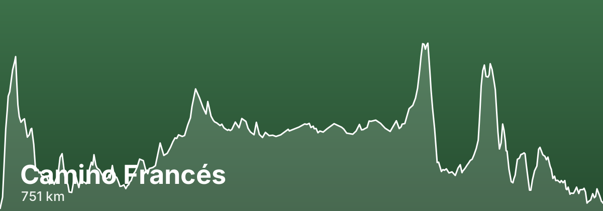
Camino Francés
Beyond the Pyrenees crossing, the Camino Francés threads across four Spanish regions - Navarra, La Rioja, Castilla y León and Galicia - passing through historic cities like Pamplona, Burgos and León before entering the green hills of Galicia. Because it is the most travelled route, waymarking is excellent and pilgrim infrastructure (albergues, cafés, and services) is denser here than on any other Camino, making it a reassuring choice for first-time walkers. Its variety of landscapes and its many towns steeped in pilgrimage history give the route its enduring reputation as the classic Way.
- ~751 kmtotal distance
- 33stages
- 769 kmofficial distance
- ~33-35 days at roughly 20-25 km/daytypical days
- Late May to June, and September into early Octoberbest season
Highlights
- Crossing the Pyrenees from Saint-Jean-Pied-de-Port to Roncesvalles
- The Gothic cathedral of Burgos and the cathedral of León
- The long, open Meseta between Burgos and León
- The Cruz de Ferro above Foncebadón, where pilgrims leave a stone
- Entering Galicia over O Cebreiro and the final green stages to Santiago
Stages
| # | Stage | Distance | Elevation | Difficulty |
|---|---|---|---|---|
| 1 | Saint-Jean-Pied-de-Port → Roncesvalles · guide → | 23.1 km | ↑1223 ↓500 m | Strenuous |
| 2 | Roncesvalles → Zubiri · guide → | 21 km | ↑179 ↓584 m | Moderate |
| 3 | Zubiri → Pamplona · guide → | 21.2 km | ↑98 ↓197 m | Moderate |
| 4 | Pamplona → Puente la Reina · guide → | 21.8 km | ↑277 ↓374 m | Moderate |
| 5 | Puente la Reina → Estella · guide → | 21.4 km | ↑248 ↓173 m | Moderate |
| 6 | Estella → Los Arcos · guide → | 20.8 km | ↑251 ↓219 m | Moderate |
| 7 | Los Arcos → Logroño · guide → | 26.8 km | ↑180 ↓260 m | Moderate |
| 8 | Logroño → Nájera · guide → | 27.9 km | ↑291 ↓172 m | Moderate |
| 9 | Nájera → Santo Domingo de la Calzada · guide → | 21.1 km | ↑246 ↓106 m | Moderate |
| 10 | Santo Domingo de la Calzada → Belorado · guide → | 22.1 km | ↑202 ↓72 m | Moderate |
| 11 | Belorado → San Juan de Ortega · guide → | 23.4 km | ↑384 ↓135 m | Moderate |
| 12 | San Juan de Ortega → Burgos · guide → | 25.6 km | ↑111 ↓251 m | Moderate |
| 13 | Burgos → Hornillos del Camino · guide → | 19.9 km | ↑81 ↓114 m | Moderate |
| 14 | Hornillos del Camino → Castrojeriz · guide → | 19.6 km | ↑101 ↓138 m | Moderate |
| 15 | Castrojeriz → Frómista · guide → | 24.7 km | ↑150 ↓172 m | Moderate |
| 16 | Frómista → Carrión de los Condes · guide → | 18.7 km | ↑58 ↓12 m | Moderate |
| 17 | Carrión de los Condes → Terradillos de los Templarios · guide → | 28.6 km | ↑85 ↓65 m | Moderate |
| 18 | Terradillos de los Templarios → El Burgo Ranero · guide → | 28.4 km | ↑116 ↓89 m | Moderate |
| 19 | El Burgo Ranero → Mansilla de las Mulas · guide → | 18.4 km | ↑0 ↓77 m | Moderate |
| 20 | Mansilla de las Mulas → León · guide → | 18.3 km | ↑115 ↓79 m | Moderate |
| 21 | León → Villar de Mazarife · guide → | 20.3 km | ↑85 ↓33 m | Moderate |
| 22 | Villar de Mazarife → Astorga · guide → | 27.3 km | ↑127 ↓143 m | Moderate |
| 23 | Astorga → Foncebadón · guide → | 25 km | ↑571 ↓9 m | Challenging |
| 24 | Foncebadón → Ponferrada · guide → | 27.1 km | ↑173 ↓1085 m | Challenging |
| 25 | Ponferrada → Villafranca del Bierzo · guide → | 22.3 km | ↑131 ↓150 m | Moderate |
| 26 | Villafranca del Bierzo → O Cebreiro · guide → | 27.2 km | ↑819 ↓31 m | Challenging |
| 27 | O Cebreiro → Triacastela · guide → | 20 km | ↑168 ↓774 m | Moderate |
| 28 | Triacastela → Sarria · guide → | 17.1 km | ↑260 ↓489 m | Moderate |
| 29 | Sarria → Portomarín · guide → | 21.5 km | ↑277 ↓361 m | Moderate |
| 30 | Portomarín → Palas de Rei · guide → | 24.5 km | ↑391 ↓209 m | Moderate |
| 31 | Palas de Rei → Arzúa · guide → | 28.2 km | ↑274 ↓455 m | Moderate |
| 32 | Arzúa → O Pedrouzo · guide → | 18.9 km | ↑172 ↓245 m | Moderate |
| 33 | O Pedrouzo → Santiago de Compostela · guide → | 18.8 km | ↑199 ↓229 m | Moderate |
Long but rarely technical, with the steep Pyrenees crossing at the start, the exposed flat Meseta in the middle, and a demanding climb to O Cebreiro before Galicia.
Distances and elevation come from real OpenStreetMap footpath geometry. In the planner you can split or merge any stage to match your pace.
Where to stay — Camino Francés
- Roncesvalles 4 albergues · 6 hotels · book
- Zubiri 6 albergues · 7 hotels · book
- Pamplona 13 albergues · 22 hotels · book
- Puente la Reina 9 albergues · 4 hotels · book
- Estella 9 albergues · 4 hotels · book
- Los Arcos 6 albergues · 3 hotels · book
- Logroño 13 albergues · 22 hotels · book
- Nájera 5 albergues · 6 hotels · book
- Santo Domingo de la Calzada 4 albergues · 5 hotels · book
- Belorado 7 albergues · 6 hotels · book
- San Juan de Ortega 2 albergues · 2 hotels · book
- Burgos 19 albergues · 25 hotels · book
- Hornillos del Camino 3 albergues · 2 hotels · book
- Castrojeriz 10 albergues · 10 hotels · book
- Frómista 8 albergues · 4 hotels · book
- Carrión de los Condes 6 albergues · 4 hotels · book
- Terradillos de los Templarios 2 albergues · book
- El Burgo Ranero 3 albergues · 3 hotels · book
- Mansilla de las Mulas 4 albergues · 4 hotels · book
- León 18 albergues · 22 hotels · book
- Villar de Mazarife 1 albergues · 2 hotels · book
- Astorga 6 albergues · 8 hotels · book
- Foncebadón 6 albergues · 2 hotels · book
- Ponferrada 7 albergues · 12 hotels · book
- Villafranca del Bierzo 8 albergues · 9 hotels · book
- O Cebreiro 4 albergues · 5 hotels · book
- Triacastela 7 albergues · 7 hotels · book
- Sarria 21 albergues · 23 hotels · book
- Portomarín 16 albergues · 12 hotels · book
- Palas de Rei 13 albergues · 5 hotels · book
- Arzúa 20 albergues · 11 hotels · book
- O Pedrouzo 14 albergues · 10 hotels · book
- Santiago de Compostela 21 albergues · 40 hotels · book
Frequently asked questions
How long is the Camino Francés?
About 751 km, usually walked in 33 stages (~33-35 days at roughly 20-25 km/day).
When is the best time to walk the Camino Francés?
Late May to June, and September into early October
How hard is the Camino Francés?
Long but rarely technical, with the steep Pyrenees crossing at the start, the exposed flat Meseta in the middle, and a demanding climb to O Cebreiro before Galicia.